


 Your new post is loading...

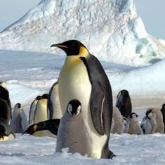

High-resolution imaging has allowed scientists to produce the first full count of Antarctica's emperor penguins...
Before this, there was no way to to gather reliable penguin statistics. Geospatial technologies are now providing us the tools to teach us more about the biogeography of penguins. The applications of geospatial technologies are endless.


In the beginning of the semester we talked about how geography is always changing. Our understanding of geography does as well. This new technology helps people have a clearer picture of the wildlife that exists on Antarctica. Because of its harsh environment the amount we know about this barren continent has been limited. As technology improves we will be able to gain more accurate information about Antarctica.
Using this new technology, animal can be monitored and helped by the satellites. Having a way to accurately know the population of a species is incredible, because now we can know which species are in danger of extinction and we can take steps to help them. Before the use of the satellite, the population of Emperor penguins was found to be 595, 000 and the colonies of penguins was found to be 46 instead of the previous 38, so without this technology there have been penguins that may have needed help, but now they will get proper attention.
Technology never ceases to amaze me. As the article described, the use of satellite imagining recently showed that the “population count” of the emperor penguin is “found nearly twice as many...as did previous studies.” Prior to the use of satellite imaging, the method to obtain this type of data was done by people actually being around the area. As the new numbers showed this was inaccurate because so much of the artic can’t be reached by the human population. I think this brings up an interesting notion. We define our landscape based on what we see. Yet, what we see doesn’t always capture what is actually on earth. As such, I wonder if more penguin colonies have disappeared then the one the British intuition noticed. We won’t know, but at least now thanks to technology a better grasp of the situation can happen. Maybe with more concrete data about the effects of global warming on Antarctic more non-believers could be swayed. All in all, I think the technology is beneficial. The only down side about this technology is the possibility for misuse. If we can now figure out the penguin population down to which ones are adults, imagine just what else this technology can due in the name of “geographic research.”